Author Archives: Courtney
Can sewage save us?
To survive rising seas, Boston may need to ‘make’ land again
The uneven rise of the healthy workplace
Mapping vacant lots in Boston
The COVID-19 pandemic has highlighted many social injustices; one of them is access to outdoor spaces. In recent years, researchers have documented how urban neighborhoods that are poorer or have large minority populations tend to have fewer parks or limited access to safe and high-quality open spaces. People living in Black neighborhoods in Boston, for instance, are less likely to have access to recreational spaces. This issue became more acute in 2020 when people flocked to parks to relax, exercise, and socialize outdoors, where risk of COVID-19 transmission is much lower. Having access to high-quality outdoor spaces became more than an amenity; it was essential for many people’s mental health. Outdoor space also helped neighborhoods and businesses maintain some level of normalcy, like the Lawn on D in gentrified South Boston that was transformed into an outdoor eatery.
The need for outdoor spaces won’t go away this year, as is clear by rising infection rates and slow vaccination schedules. Looking beyond this pandemic, green spaces will become increasingly important in urban areas for their ecological functions as the climate changes: helping to cool cities and absorb stormwater, and give people shady spaces to gather or stop along a walk or bike ride.
There are opportunities to rectify unjust greening. One of the legacies of Boston’s history of redlining and racial segregation is a large number of vacant lots in neighborhoods with large populations of Black residents, such as parts of Roxbury, Dorchester, and Mattapan. In urban areas, vacant space reflects larger social and economic uneven development, but is often rooted in policy, whether it’s a deliberate choice to set aside land, a side effect of sanctioned neighborhood change, or deliberate disinvestment. Vacant lots can represent many things to residents: abandonment, neglect, nature, possibility.

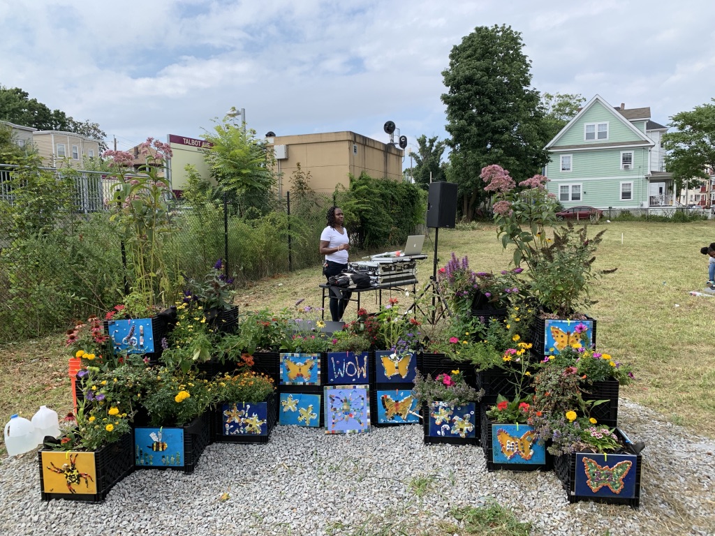
Several groups have been working to create new possibilities for Boston’s vacant parcels. In 2019, as part of a UMass Boston course called the Innovation Clinic, I had an opportunity to be involved in one neighborhood’s efforts to transform a vacant lot into a park. The West of Washington Street (WOW) Coalition is a dynamic neighborhood group that has initiated a number of improvements in an area of Dorchester near Codman Square. My student team worked with WOW and the Trust for Public Land to design and implement a temporary milk-crate pollinator garden in the lot as a way to activate the space during the ongoing planning process. I helped to organize and lead a volunteer day in the neighborhood to construct the garden, and then led a community artwork event during the neighborhood’s summer barbecue, in which community members used mosaic materials to decorate the milk crates with pollinator-themed artwork.
During the course of the project, my team was interested in how the park on Norwell Street fit into the larger context of transit and green space equity in Boston. The park-to-be will serve as an important landmark along the Fairmount Greenway, a 9-mile walking and bicycling route that would connect existing and new open space along the Fairmount Commuter Rail line in Roxbury, Dorchester, Mattapan, and Hyde Park. But unlike some of the city’s well-known greenways, this is largely a grassroots effort that will hopefully be stitched together over many years of planning and effort, bringing green space and improved mobility to these historically underserved neighborhoods. The Fairmount Indigo CDC Collaborative has created a 10-member Fairmount Greenway Task Force (FGTF) to work on creating the greenway, particularly through transforming vacant lots into parks, community gardens, urban farms, and other community spaces. With a grant from the TPL, the task force has been working to identify and map parcels that could serve as potential open spaces for neighborhoods along the corridor, and to engage neighborhood groups in planning.
With some leftover funding from the Innovation Clinic project, in the summer of 2020 I worked with Michelle Moon, a planner with the Fairmount Greenway Task Force, to map around 500 vacant parcels under city ownership through the Department for Neighborhood Development, which included categories that the DND had previously assigned to the parcels for potential uses. Because these sprawling neighborhoods are divided into numerous different communities, we created a series of small-scale maps that would help each community along the Fairmount Line visualize how vacant lots fit into the existing urban fabric and imagine how they might best be used.
While this was a brief project, it serves as a small piece in a long-term effort to bring more needed open space to Boston’s neighborhoods. FGTF hopes to continue lobbying policymakers and elected officials for more investment in open spaces; along with Dorchester Climate Justice, they have developed a “green paper” arguing for additional investment from the Parks Department for vacant lots in neighborhoods along the corridor. This effort addresses both social and environmental justice issues, as open space can help bring communities together, provide amenities, allow for better local food production, and preserve vegetated areas that will help absorb stormwater and keep neighborhoods cool as the climate changes.
